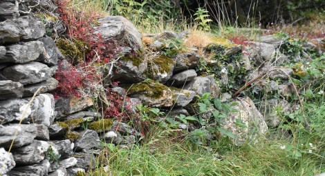
A low stone wall morphs into a natural rock garden.
Ruins and abandon sites intrigue me. They set my mind a’wandering, sending me off on flights of fancy. Who once lived there? What work did they do? How did they live their lives? Exploring ruins gives me a sense of connection to those before me, of being a part of the stream of humanity. But I connect with ghosts. Time has set me apart from them. There will always be unknows about the men and women of these sites regardless of how much is known of them. If I gave you a hundred facts about my life, you can glean some understanding of me but would you really know me?
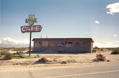
Boarded up and abandon, the High Vista cafe is left to crumble in the Californian desert.
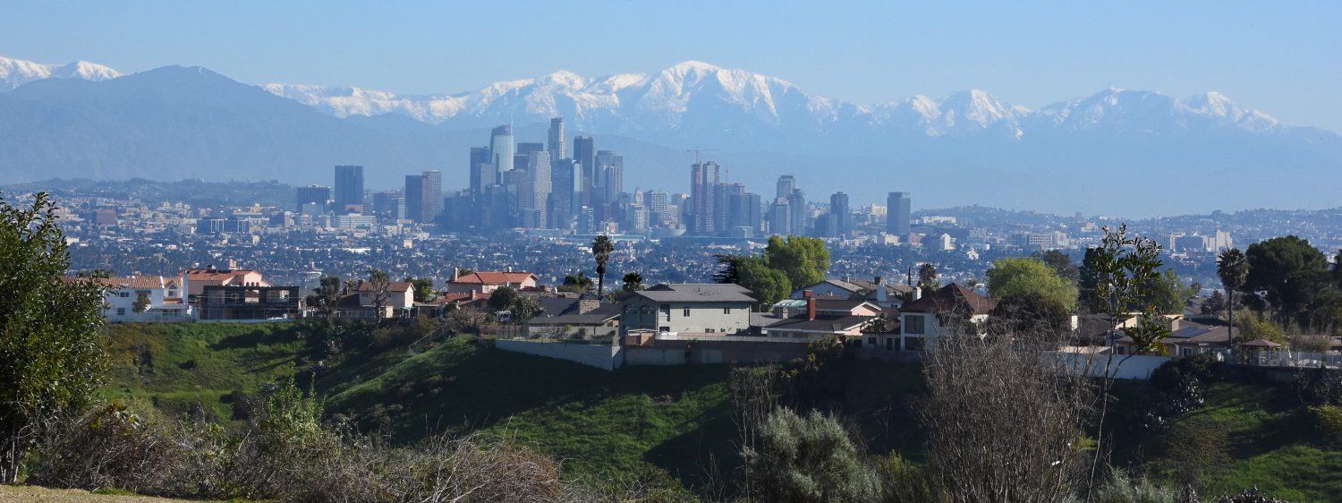
The age of the site doesn’t matter – a boarded up cafe in the desert, the silent cliff dwellings of Mesa Verde, or an abandon ranch in the hills above L.A. (see Murphy Ranch: Nature, Graffiti, Intrigue) – they all have stories that we can only guess at.
Equally fascinating is nature’s reclamation of them, from the unrelenting beating of the weather to the seed rooting between floor boards to the animal nesting in a little crevice. It is a reminder, that in the urban wilderness, the wilderness often ends up victorious.
“They’re still rocks,” my 11 year old’s observation.
This summer I traveled to Ireland. I had plenty of opportunity to explore some of the buildings and dwellings that have been left behind, much to the horror of my son. “We could have stayed home if you wanted to look at rocks.” “Yes, but look at how these rocks are stacked.” “They’re still rocks!”
Some of the ruins were a few hundred years old, others, relics from a far past, shrouded in the mist of thousands of years.
The devil went down to Georgia, but first he stopped in Ireland…
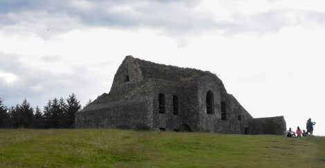
South of Dublin rises a range of low mountains that make for a pleasant outing from the city. A hike up the slope of Montpelier Hill brought me to the shell of an old hunting lodge built in the seventeen hundreds. Hunting, though, was the least interesting activity that took place there. The old lodge is referred to as the Hell Fire Club where young aristocrats gathered to drink, gamble, and carouse. But tales grew up that are more entertaining. Black masses, animal sacrifices, and sexual indulgences were among the rumored activities. One story tells of a stranger that came one night and joined the young bachelors in a game of cards. Dropping a card on the floor, one player bent under the table to pick it up and saw the feet of the stranger. A pair of cloven hooves. At that point, the stranger disappeared in a poof of fire.
Hellfire Club overlooking Dublin
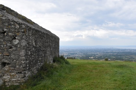
Today, at least during daylight, the devil is unlikely to appear. The dark gray stone building sits in a grass field by the mountain top. The edges of the building are ragged and worn leaving no sharp edges. Overlooking Dublin, the lodge provided for a panoramic view of the city. Despite their age, the walls appeared solid and sturdy. The building material certainly is, many of the stones coming from an ancient burial mound that was originally there.
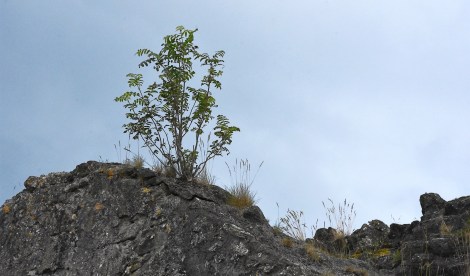
On the roof of the Hellfire Club, a small bush takes root.
In the crack and crevices of the stone walls, various plants take root. Mostly small annuals or perennials, but on the roof top grew a bush. It’s life may be short, but its roots will seek out the tiniest of cracks in the mortar, slowly widening them as they grow. Where two walls meet was a grotto of ferns and wildflowers. Left untended, these plants and their roots will eventually tear down this stone building.
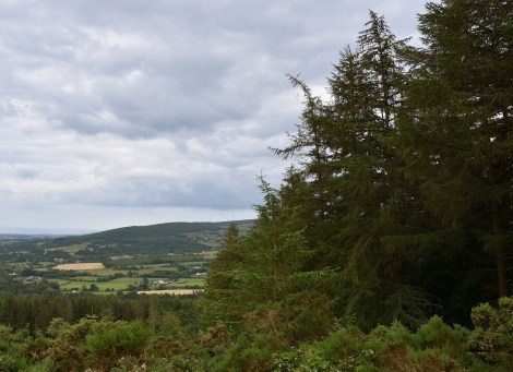
Many hillsides in Ireland are covered with thick conifer forests. However, these aren’t ancient woodlands but recent additions.
The mountains continue south forming the Wicklow Mountains. Thick conifer forests cover the slopes. The remains of the ancient woodlands of Ireland? No. These forests are tree plantations, some to be harvested for timber, some to help Ireland fulfill its EU quota for forested areas to meet carbon reduction goals. None of it ancient or native. The conifers are, for the most part, Sitka spruces far from their Alaskan homeland. The native hardwood trees that once covered these slopes are rare now. Sadly, these woods can be ecological dead zones, providing little food for the native animals or a healthy habitat for the undergrowth once found in the hardwood forests. Nor may they be helping much with offsetting carbon, as the planting of these forests destroyed many acres of peat bogs that sequestered more carbon than the trees could. For more about the Sitka forests, see the article A forestry boom is turning Ireland into an ecological dead zone.
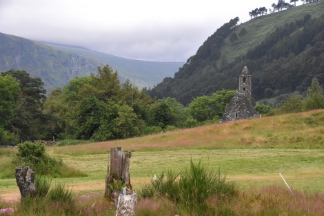
St. Kevin’s Kitchen, actually a church, sits in the serene Glendalough Valley.
At the southern end of the Wicklow Mountains lies Glendalough Monastery. Founded in the sixth century by St. Kevin, this monastery was central to the people in the region. At the time Ireland was a land without towns or cities. Farmers and trade people were scattered throughout the region. The monasteries served not just as religious centers but as economic hubs. Glendalough was bustling with activity in its time, but now, sitting the forested mountain valley, it appears as a serene retreat surrounded by meadows with a gentle river flowing by. A Irish Shangri La, perhaps.
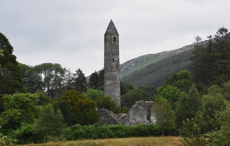
The round tower rises above the ruins of Glendalough Monastery. Round towers were thought to have been used as refuges during Viking raids. However, current thinking is they function as a belfry for the monastery’s church. The Irish name for round tower is cloigtheach, which means bellhouse.
Well, maybe not that serene. Tourists, brought down from Dublin by tour buses, now fill the monastery. Yet on the short hike to the ruins, the crowds are hidden by the trees and shrubs growing around the old buildings. Above the tree line, like a beacon, rises the round tower, some ninety feet high, overlooking the valley. It gave me the feeling of entering a time long gone.
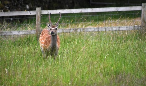
In a meadow next to Glendalough browses a fallow deer. Fallow deer (Dama dama) are Ireland’s most widespread deer though they aren’t native to the island. They were likely brought over by the Anglo-Norman invaders in the 13th century.
There is a sense of the abbey and meadows and forests around it existing in a state of harmony. But the truth is probably the opposite. The people there were wrestling their existence from nature, cutting down the trees for buildings and firewood, and for opening up land for farming or grazing. Yet they were still at nature’s mercy where a dry year could mean failed crops as would a year with too much rainfall.

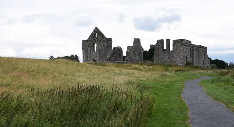
Now surrounded by a sheep pasture, Kells Priory was a major religious center.
These early monasteries were a bit of freewheelers, outside the control of Rome. By the 12th century, the Catholic Church had enough of their shenanigans and sent in Dominicans and Augustines to get things back in order. Kells Priory, south of Kilkenny and west of Glendalough, was founded in 1193 by the Augustines. Not the Kells Priory of the Book of Kells fame, this monastery is surrounded by sheep pastures. Getting to the old priory demands careful attention as you tiptoe around the sheep dung.
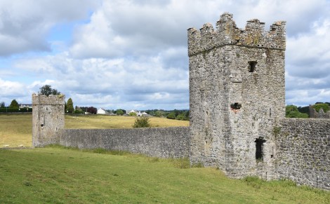
The outer walls and fortified towers at Kells. These inspired the monastery’s local name ‘Seven Castles.’
One of the largest religious centers in Ireland, Kells is surrounded by a tall stone wall with fortified towers. Not what one would expect at a religious center, but the priory was attacked and burn several times in its history. Today it is rather peaceful.

Cathedral wall at Kells.
Kells was off the main tourist route and not visited by the big tour buses. We wander around the ruins with only a few other visitors. Without the crowds, Kells is a magical place, where, if one listens hard enough you might hear the voices of its ghosts.
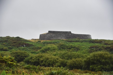
Cahergal Stone Fort, built around 600 AD.
Equally magical are the ring forts scattered through Ireland. Mostly built between 500 to 1000 AD, the forts owe their current existence to legends and fairy tales. People believed them to be fairy forts, and misfortune waited for anyone who dared to remove a stone from them. In reality, the ring forts were more mundane. Some were the stronghold for chieftains and minor kings, others homestead of wealthier landowners, still others served the unglamorous purpose of livestock pens.

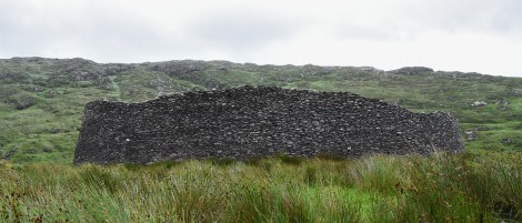
Entrance to Staigue Fort.
I visited Staigue Fort on the Kerry peninsula. Walking up to the stone ring, it was easier to imagine them occupied by an ancient race of elves rather than some boisterous chieftain and his cattle. Staigue Fort sits on a low hilltop, surrounded by rugged hills covered in rich green with cold clouds dragging along their peaks.

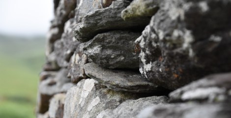
Deceptively simple, these stack stone walls have stood for a thousand years without the use of mortar.
It was beautifully made. The circular walls that formed the ring are thirteen feet thick at the base and as high as eighteen feet. The enclosed area has a diameter of ninety feet. Within the walls once stood homes. Made only of stacked stones, the wall has stood steadfast for over a millennium, held in place by the careful placement of the stones. No mortar was used.
Staigue Fort blends in with the stony hills.
Uninhabited for hundreds of years, Staigue Fort is as much a part of landscape as the surrounding hills. Sitting in a meadow of grasses and sedges, any signs of past occupation are hidden. Areas that were trampled bare by daily activities and livestock are covered by a carpet of grasses and sedges.
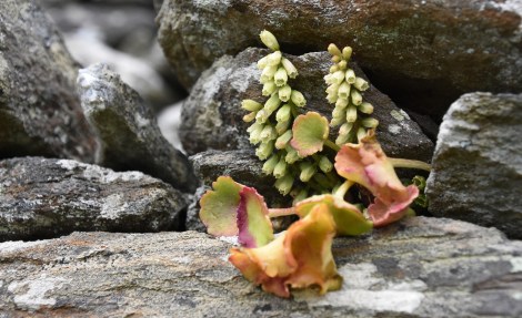
Navelwort (Umbilicus rupestris) grows on the stone wall.
Whatever shelters stood within the walls are now gone. No signs of tools and provisions can be seen. The dark gray of the stone walls match the bedrock exposed on the nearby hillsides. Staigue Fort is as much a part of the hills as is the meadows around it.
Doolough Valley is now mostly covered with a peat bog. Thousands of years ago, it was likely heavily forested.
But even without the ruin stone walls or the modern homes and businesses of the villages and towns, the impact of humans have shaped the Irish landscape. The green slopes, rolling fields and peat bogs may appear as nature intended, but they are as much a product of humans as nature. (For a quick explanation of peat bogs, see Ireland’s Peat Bogs.) Ireland today is one of the least forested countries in Europe. Yet when the first settlers arrived it was heavily forested with hardwood trees – oaks, beeches, and elms. But these weren’t ancient forests that have grown since the dawn of time. They grew in thin soils in a land that not too long ago was covered in ice. The settlers cut down the trees faster than they could grow back. In their place came a new landscape.
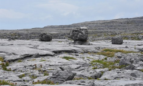
The limestone bedrock of the Burren was exposed in the last Ice Age creating a surreal landscape.
The Burren is an example of this natural landscape made by both people and nature. Like most of Ireland, the land is beyond ancient. The limestone bedrock of the Burren formed over 300 million years ago when this part of Ireland was under the sea near the equator. Centuries of marine life dying and settling on the ocean floor created the limestone, blurring the line between organic and inorganic. Stone made not of lava, but of millions of dead clams.
The Burren is an example of a Glacio-Karst landscape. Karst refers to a landscape that consists of an exposed limestone bedrock. The ‘Glacio’ refers to the bedrock having been scoured by glaciers.
As the eons passed, geological forces carried the limestone northward and upward till what was once the sea bottom is now dry land. What life first looked like there, what flora and fauna might have covered the area are lost. Around 10,000 years ago temperatures dropped and enormous glaciers scoured the land, pushing out all life. For thousand of years ice sheets covered the Burren. As the ice retreated they left behind exposed bedrock and stone rubble.
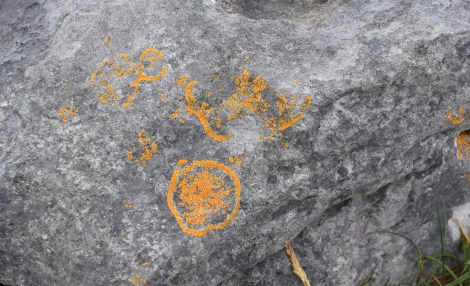
Lichen is often the first living organism to colonize rocky terrains. Lichens is actually two organisms in one – a fungi and an alga that form a symbiotic relation.
At the time, Ireland and Britain were connected to the European mainland. As the glaciers pulled back, lichen and mosses got a foothold on the new stone. Soon small plants took root in the cracks and gravel beds. Soil began to be formed and larger and larger plants appeared. As the climate continued to warm, the forests of Central Europe grew northward, spreading into Ireland.

Thrift (Armeria maritima) is one of the plants found growing in the crevasses of the rocks.
However 10,000 years is a moment in geological time. In most of Ireland, the Burren especially, the new soil never got too deep. It was held in place by the roots of the newly arrived trees. As the ice continued it’s retreat northward, the ocean rose and Ireland and Britain became islands. The northward spread of plants and animals into Ireland stopped.

This portal tomb, Poulnabrone Dolmen, is a remnant of the people that lived in the Burren over 5000 years ago.
By this point, wandering tribes of humans had entered Ireland. As they expanded across the island, they cut down the trees to build homes, for firewood, and to clear the land for farming. But without the tree roots holding the dirt in place, erosion began to strip the Burren of its delicate layer of soil. The limestone became exposed again.

Fissures called grykes were formed when rain water dissolve the weaker spots in the limestone. The grykes become home to a wide variety of plants.
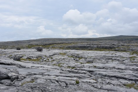
Rainwater began dissolving the limestone, forming cracks and fissures called grykes. Between the grykes was a pavement of limestone called clints. As they had thousands of years ago, plants begun again to recolonize the Burren. In this seemly inhospitable land, over 70% of all the native plants found in Ireland grow here.

Grasses, small perennials, and wild flowers make what first appears to be a lifeless place a rich garden.
Influence by the Gulf Stream, the climate of the Burren remains relatively mild year around. The combination of the mild climate and the rocky grounds results in plants from disparate regions growing near each other. Plants normally seen growing in alpine tundra can be found near plants usually found in the Mediterranean region.

The limestone ground requires constant looking down while walking in the Burren. Not only to avoid twisting one’s ankle in a gryke but also to not miss some of the fantastic rock formations.
It’s a reminder that nature will continue. What we tear down and destroy, nature reclaims and makes her own. Something to remember in these days of climate change. Nature isn’t in trouble. We – as well as the thousands of species we’ll take down with us – are. In the end, nature always win.

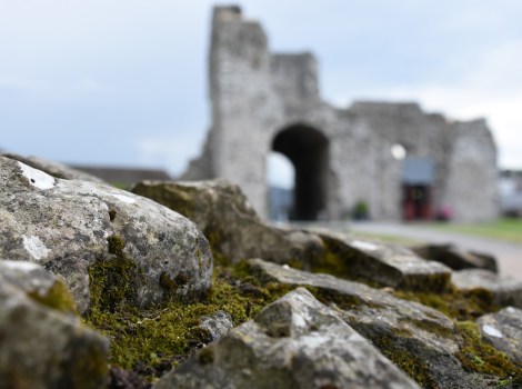
The outer walls of Trim Castle. Notice the bedrock the wall in the center sits on.
Back on the eastern side of Ireland, I thought of the Burren as I wandered around Trim Castle. The largest of the Anglo-Norman castles in Ireland, the castle was one of many built to support England’s first invasion into Ireland. The castle would have been a formible obstacle to any enemy. A river on one side, the rest of the castle was surrounded by a moat. The walls were built on the bedrock so they couldn’t be tunneled under. In the center was a seventy foot high tower built with walls several feet thick. Though time has been hard on it, much of it still stands.
Lichen slowly colonized the ruins of a wall.
The stone walls and ruins are like a miniature version of the Burren when the glaciers retreated. On the rock face and in the crevices, lichen clings to the rock slowly growing and dissolving stone. Mosses and algae join in, preparing the way for more complex plants.

The remains of one of the defensive towers become a grotto full of plants.
As dirt, dust, and dead organic material gather in the cracks, small plants colonize the rock face of the walls and buildings, digging roots into the mortar. So once again begins the slow task of turning bare stone into soil.
Once sitting on the edge of a new town called, well, New Town, St. Peter and St. Paul Cathedral now resides next to a large grass pasture.
A short walk from Trim Castle sand the remains of St. Peter and Paul Cathedral. Like the other ruins, lichen and moss cover the stones and plants find purchase in the cracks. The sun was getting low in the sky and standing among the old walls, I felt a sense of unease, a feeling of foreboding.
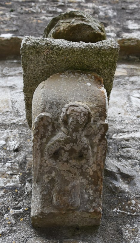
Even angels aren’t spare the indignities of time and weather.
The graves and tombstones surrounding the old cathedral heightened that feeling, but it was the murder of crows swooping in and out of the ruins giving me the chills. Their caws filled the air as if agitated by some unseen presence. Perhaps an old wraith whose solitude I’ve disturbed? Turns out that the crows weren’t ominous omens, just harried parents. In the old walls were holes arranged in columns and used as nesting sites. Bringing food to the nest, the crows would swoop in and out of the holes feeding their young.
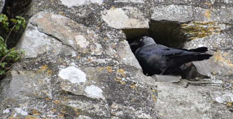
A jackdaw (Corvus monedula) uses one of the alcoves in the cathedral walls as a nesting site.
These crows are called jackdaws (Corvus monedula). Growing up in the United States, I was familiar with only one crow – the solid black American crow – and the larger raven. The jackdaws are smaller than their American cousins. Nor are they all black. The back of their head and neck is colored a dusty grey and their eyes are a bright bluish white. Leaving before it got dark, I left the parents to tend to their young and the wraith to its solitude.

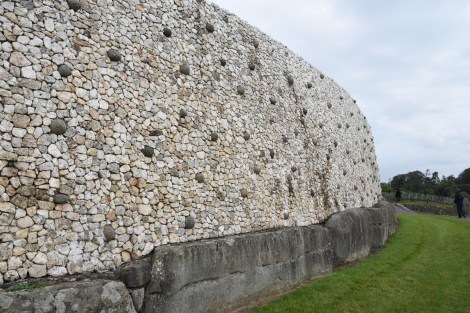
Newgrange has a diameter of 279 feet and a height of 45 feet high. It covers approximately one acre.
One of my last stops was to Newgrange. Older than the Egyptian pyramids, Newgrange is a passage tomb sitting on a hilltop. Essentially a large pile of rocks covered with dirt enclosing a narrow passage that leads to a central chamber. But this pile of rocks and dirt was carefully arranged and designed, not just tossed together.
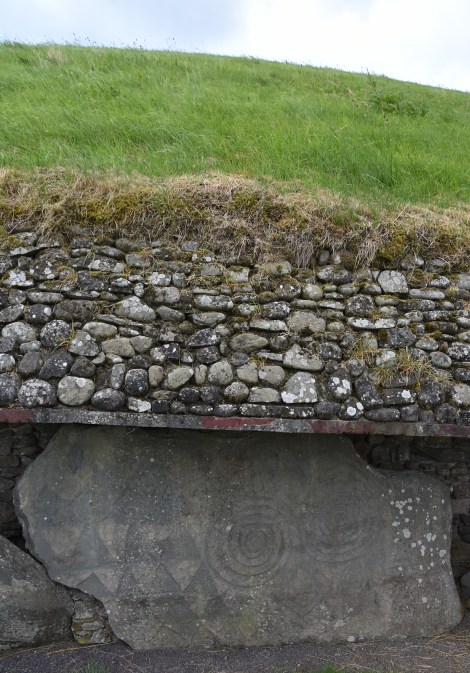
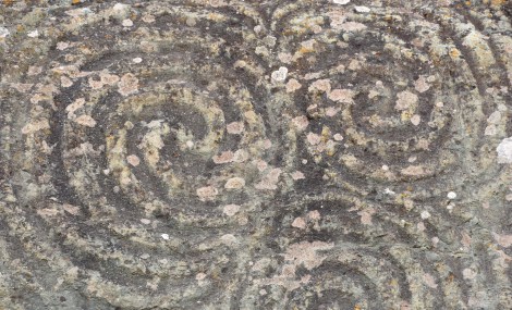
The outer base of Newgrange is made of 97 kerbstones, each weighing several tons. Some are decorated with megalithic art as seen here. However the art on the stones aren’t always visible, some are on the inner side or bottom of the stone. Obviously, the concrete slab was a newer addition put in during restoration work.
The foundation stones weighed several tons and were brought from miles away without the use of wheels or carts. The passage of the tomb is aligned with the sun’s rising at the winter solstice. Yet as the passage goes 79 feet into the mound, it rises upward so the entrance isn’t visible from the center chamber.

The portal above the main entrance. In the days surrounding the winter solstice, light from the rising sun shines into the window to light the central chamber.
Above the entrance is a little portal. Positioned so perfectly, on the six days around the winter solstice, the rising sun will form a narrow strip of light on the dirt floor of the central chamber lasting about 15 minutes. The rest of the year, the chamber sits in darkness.
The quartz wall was reconstructed from the stones found in the debris during excavation. There is some controversy if this was how Newgrange originally appeared. However the original builders did bring the quartz stones from the Wicklow Mountains over 30 miles to the south.
Like the ring forts, Newgrange has a feeling of otherworldliness. Standing in its central chamber, built over 5000 years ago, and looking up at its dome roof of large, carefully placed rock slabs gave me a sense of awe. The roof is so well made it is still water proof today. Take in account the thousands of tons of rocks and dirt weighing down on the chamber and it is an impressive feat. We would have no problem building such a mound today – large trucks and cranes move the heavy stones as bulldozers push huge piles of dirt over the mound. Craftsmen with power routers and iron tools etch the intricate spiral on the stones. Astronomers and survey teams carefully lay out the passage’s direction to align it with the winter sun.
What does it all mean? Whether referring to the passage tomb or the art work we can only guess. Our understanding of Newgrange may never be complete.
But the ancient Irish had none of that. It is estimated it would have taken 300 workers about 30 years to build Newgrange. The builders of Newgrange were organized and knowledgable, and were planners. It is also obvious these people were attuned with nature. Today how aware are we of the sun’s position? Can we point out where the sun rises and sets on the horizon during a solstice? Would we even be aware this is a pattern that repeats without fail year after year if we didn’t learn it in our science classes? It seems that most technical evolutions separates us more from nature. Not that those ancient people lived in some utopian world with nature. They needed to be attuned with nature to survive. Today we may have more facts about nature, but they had an understanding that went beyond mere facts.
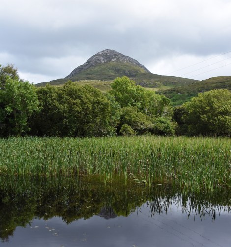
A vista in Connemara National Park calls for a return trip to wander and linger.
The trip to Ireland was a two and half week whirlwind, a couple of nights here, a couple there. This entry covered a bit of the trip, just as the trip covered a bit of Ireland. I regret I didn’t get a chance to wander its trails more or spend time idling on a hillside. But I will return. The ancient stone walls and the natural landscape will wait.
All photographs by Alan Starbuck

Ha, my favorite of your picture is the one that is not in Ireland. Is the High Vista Cafe in Hi Vista? I had to look it up, but only found that it is near Edward Air Force Base, which happens to be near Hi Vista.
LikeLiked by 1 person
It’s been a few years since I took that picture, but yes, I do believe it is near Hi Vista. I took the picture driving around the region after a hike in Saddleback Butte State Park that also is near Hi Vista. Although back then, I don’t recall any town in the vicinity.
LikeLiked by 1 person
That building could have been the town.
LikeLiked by 1 person